INNOVATION
IN AI AND ML FOR SATELLITE IMAGERY
CHALLENGES WE’VE MET AND APPROACHES


The need to automate work and minimize the work of employees (otherwise, more than 500 people were required to continue the project)

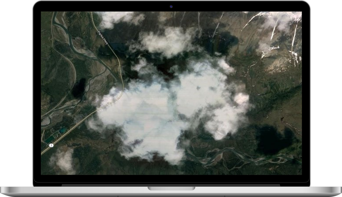
Corrupted photos (Over Exposition, blur)

Creation of well-trained segmentation model

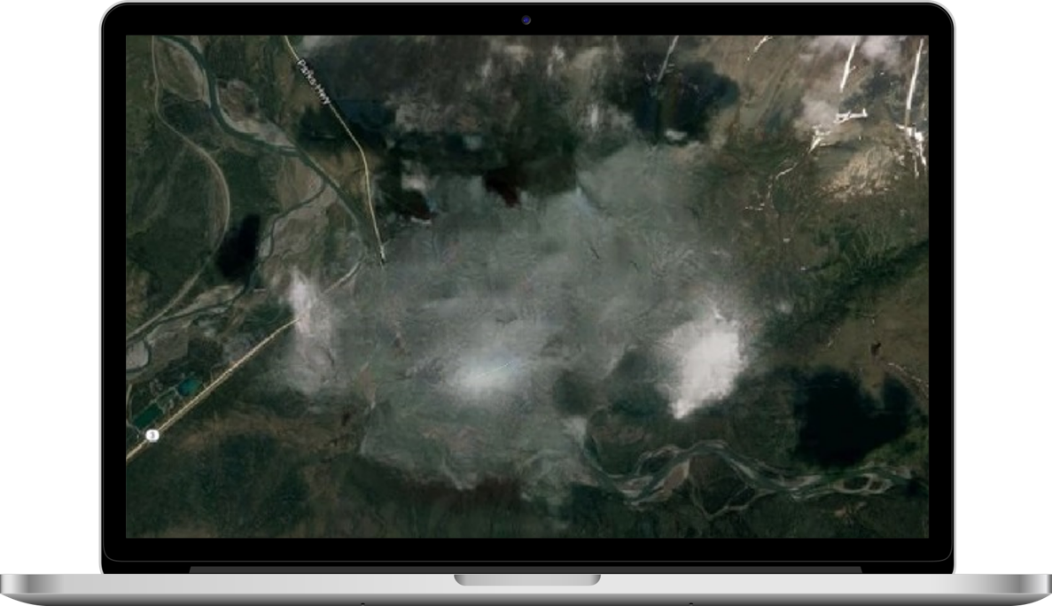
Extra objects: clouds, smoke

Impossible to classify tree types in winter time

01

AI and ML
02
RealESRGAN
03
ResNeST200
04
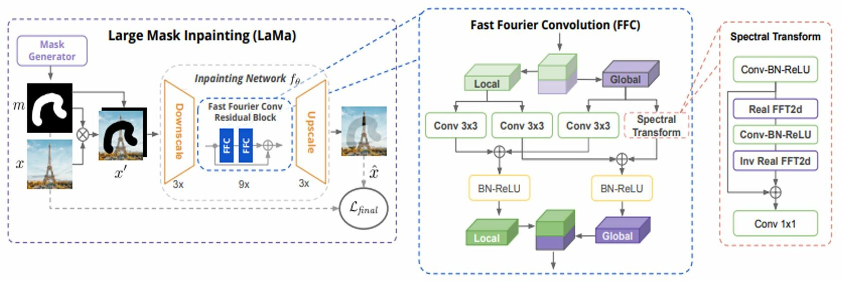
Fourier Convolutions
05
Image segmentation using HSV color space and matching with photos of flowering period
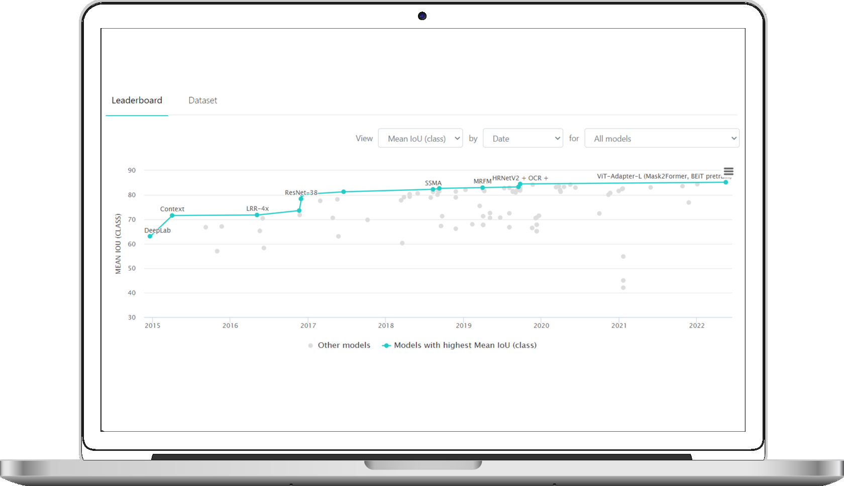
SEMANTIC SEGMENTATION WITH NEURAL NETWORKS
Befo re 2010 this task was solved with classical computer vision features:
histograms of oriented gradients (HOG), SIFT and FAST
The spread of datasets and the availability of neural networks boosted semantic segmentation task in 2010 th
NEXT most significant milestones: UNET, Deeplab, PSPNet, ResNeST, Transformers
histograms of oriented gradients (HOG), SIFT and FAST
The spread of datasets and the availability of neural networks boosted semantic segmentation task in 2010 th
NEXT most significant milestones: UNET, Deeplab, PSPNet, ResNeST, Transformers

IMPLEMENT SUPER RESOLUTION MODEL TO IMPROVE INPUT IMAGES
Used top GAN model (RealESRGAN) to increase input resolution


Model works in unpair mode. Get pairs lowers and higher images – is very complicated task
Used artificial dataset –
(highres photo, compressed
- resized-downsample-noised-photo)
(highres photo, compressed
- resized-downsample-noised-photo)
This method allowed
us to increase resolution from 1 meter/per pixel to 25 cm/pixel
us to increase resolution from 1 meter/per pixel to 25 cm/pixel
We measure dangerous trees square more acurate
Increased resolution made possible to identify types
of trees (pine, birch, spruce) and motivate partners
of trees (pine, birch, spruce) and motivate partners
RESTORED CORRUPTED IMAGES
Removed blur (UFormer)


Corrected over-exposition (add pictures instead of planes)
Satellite image restoration by nonlinear statistical filtering techniques
Bassel Marhaba, 2019
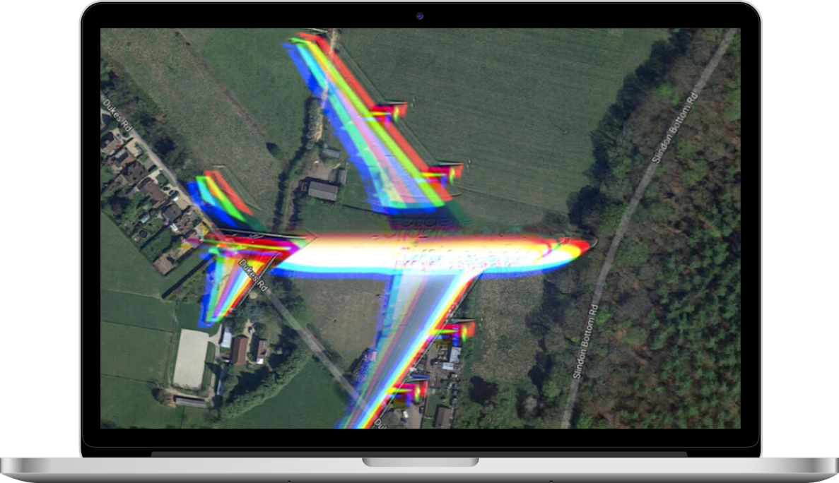
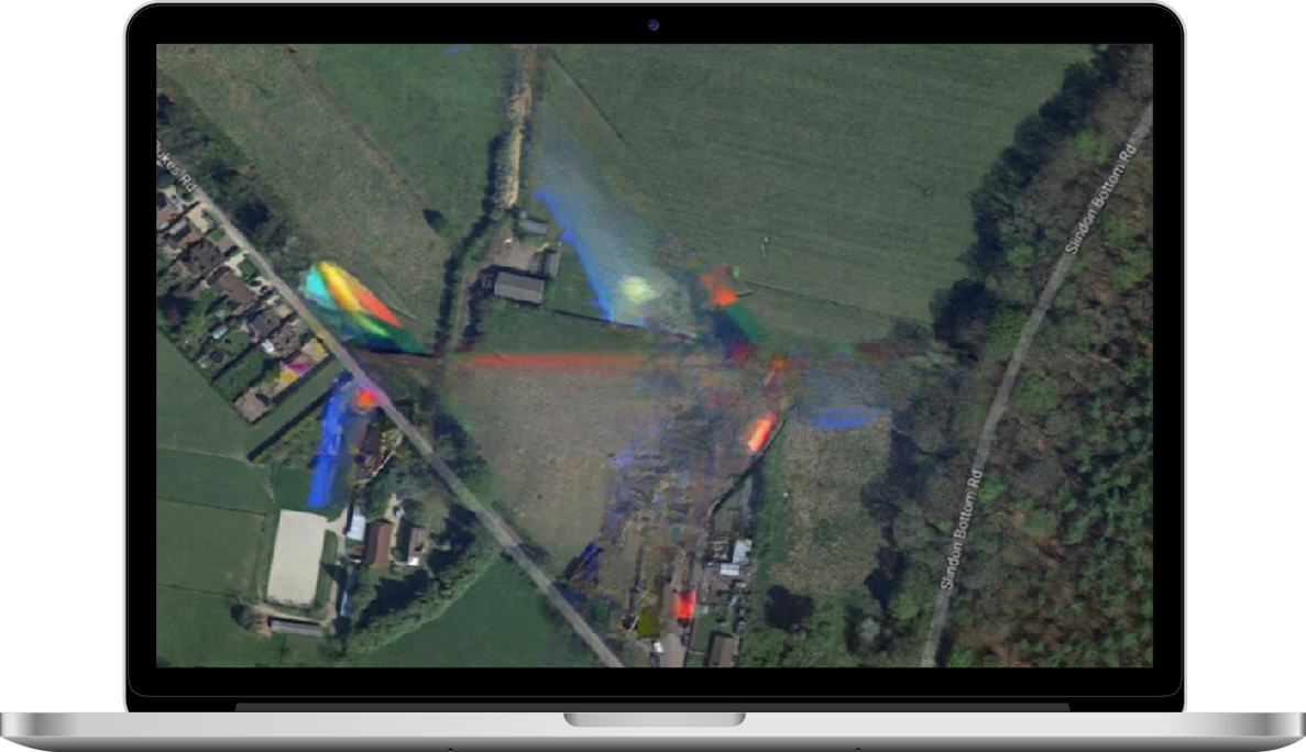
Removed small and medium extra objects with Fourier Convolutions (clouds, fog, smoke, planes, helicopters, baloons)
FEATURES DETERMINATION BASED
ON TRANSFER LEARNING (RESNETST200)
ON TRANSFER LEARNING (RESNETST200)
We made
a number
of projects based on satellite photo analysis. Our first project was segmentation
of groups of trees in electric power lines
a number
of projects based on satellite photo analysis. Our first project was segmentation
of groups of trees in electric power lines


Firstly we improve quality and resolution images
We get features based on ResNetST200
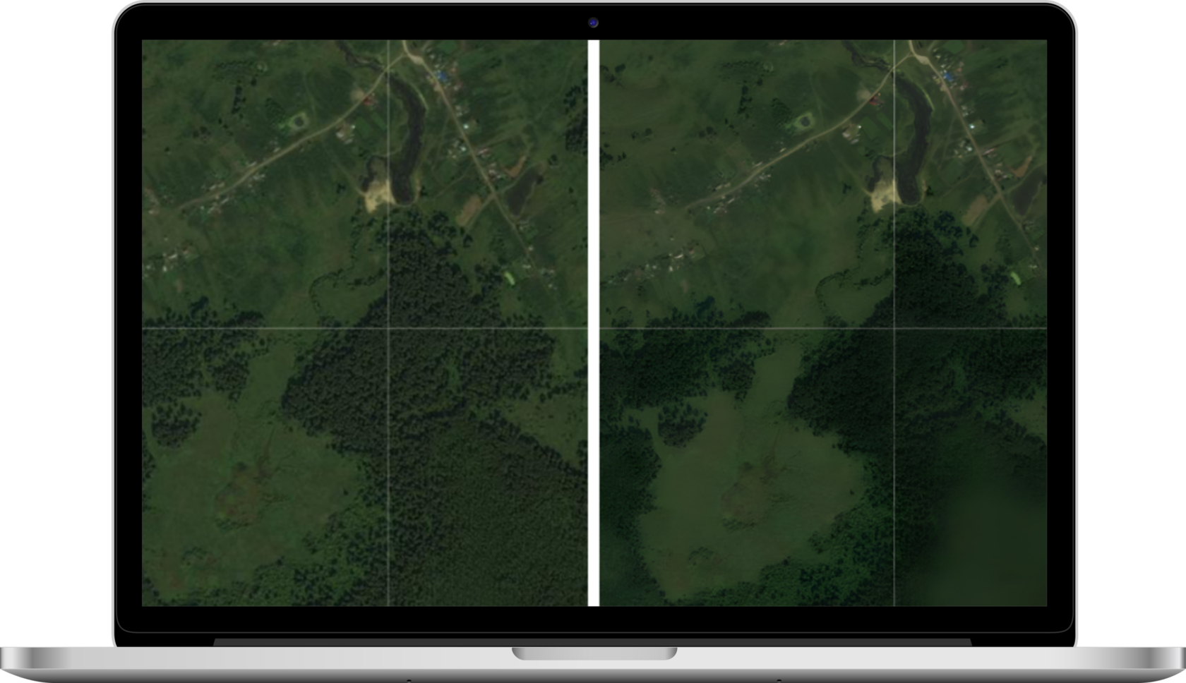
Based on segmented image we made decision:
Additionally with defined degree of height and density of forest (from 0 to 5).
0 is not needed to clear, 4-5 strongly need
to be removed
0 is not needed to clear, 4-5 strongly need
to be removed
Moreover we segmented different kinds
of trees even at winter time
of trees even at winter time
Final adjusted mean iOU is more then 96.5%
(See example on www.cmncosmos.
com)
(See example on www.cmncosmos.
com)
Not related
to problem
to problem
Clear line
Part of
problem line
problem line

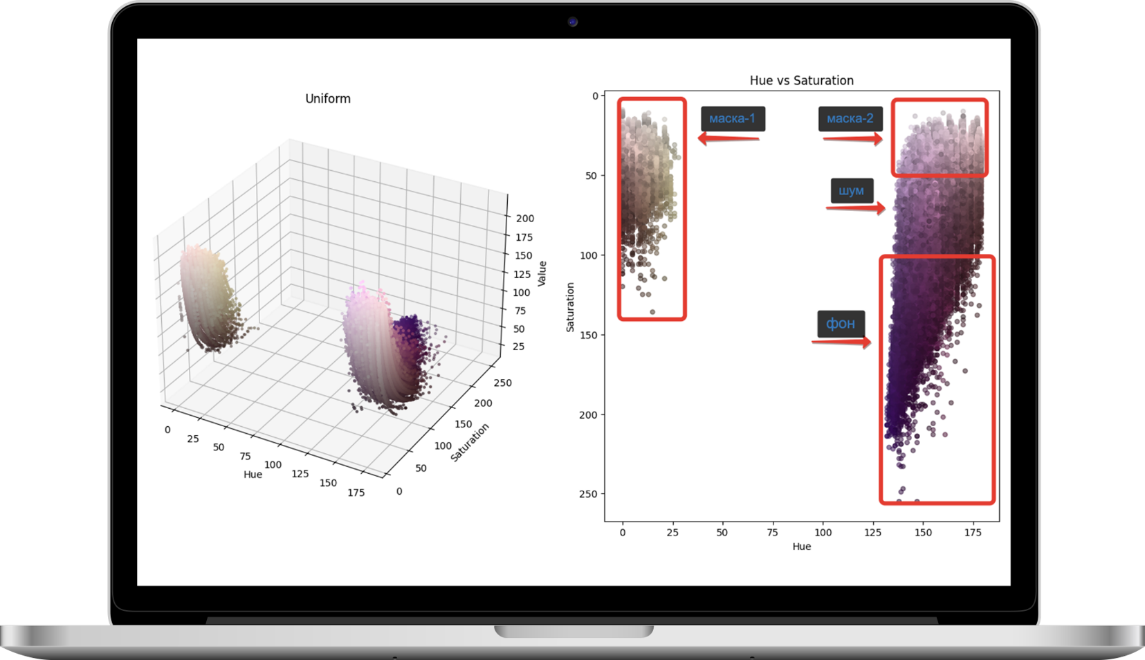
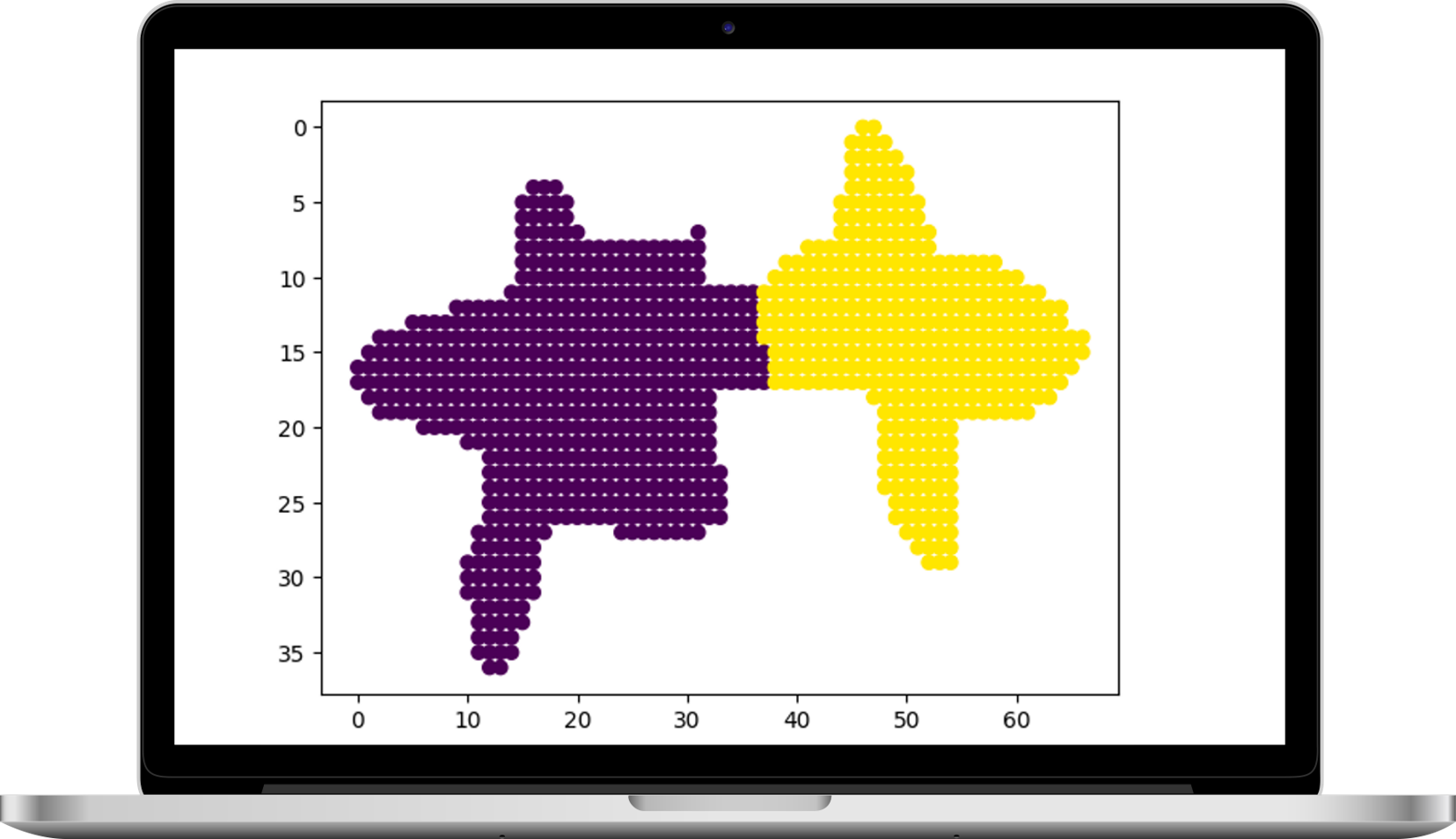
IMAGE SEGMENTATION USING HSV COLOR SPACE
# convert image to HSV color space
hsv = cv2.cvtColor(img, cv2.COLOR_RGB2HSV)
#H - 0:30, S - 0:150, V - 0:255
lower1 = np.array([0, 0, 0])
upper1 = np.array([30, 150, 255])
mask1 = cv2.inRange(hsv, lower1, upper1)
#первое облако точек
hsv = cv2.cvtColor(img, cv2.COLOR_RGB2HSV)
#H - 0:30, S - 0:150, V - 0:255
lower1 = np.array([0, 0, 0])
upper1 = np.array([30, 150, 255])
mask1 = cv2.inRange(hsv, lower1, upper1)
#первое облако точек
#H - 126:179, S - 0:50, V - 0:255
lower2 = np.array([126, 0, 0])
upper2 = np.array([179, 50, 255])
mask2 = cv2.inRange(hsv, lower2, upper2)
#второе облако точек
lower2 = np.array([126, 0, 0])
upper2 = np.array([179, 50, 255])
mask2 = cv2.inRange(hsv, lower2, upper2)
#второе облако точек
CONCLUSION
Image search based on color similarity.
For example, let's say you have a database of tree images and you want to find images that match
a given query. You can calculate the HSV color histogram for each image and compare them using
the distance metric to find the most similar images
Image search based on color similarity.
For example, let's say you have a database of tree images and you want to find images that match
a given query. You can calculate the HSV color histogram for each image and compare them using
the distance metric to find the most similar images
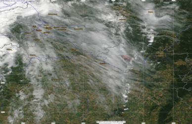
OUR (UNEXPECTED) ESG DISCOVERY
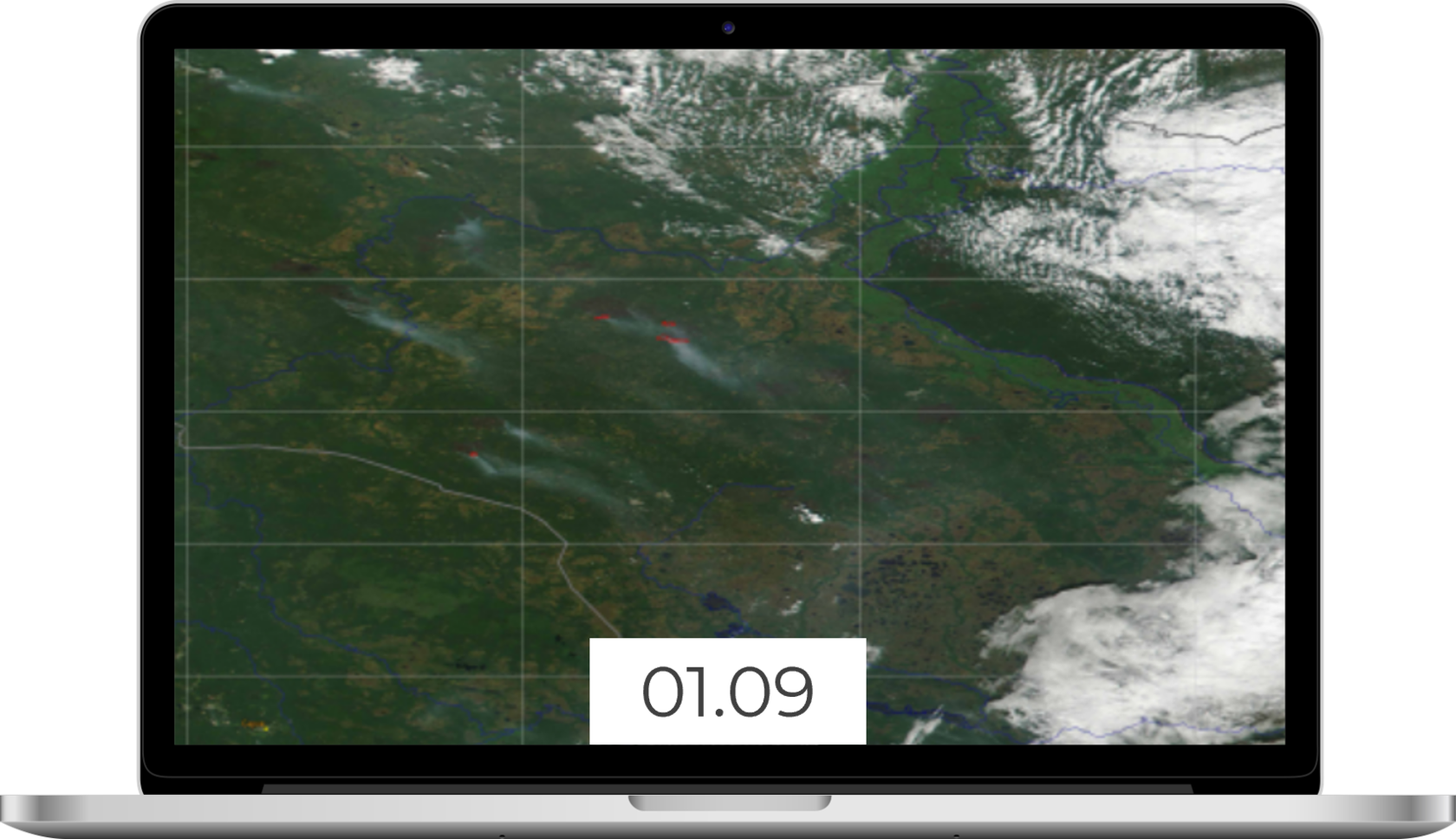
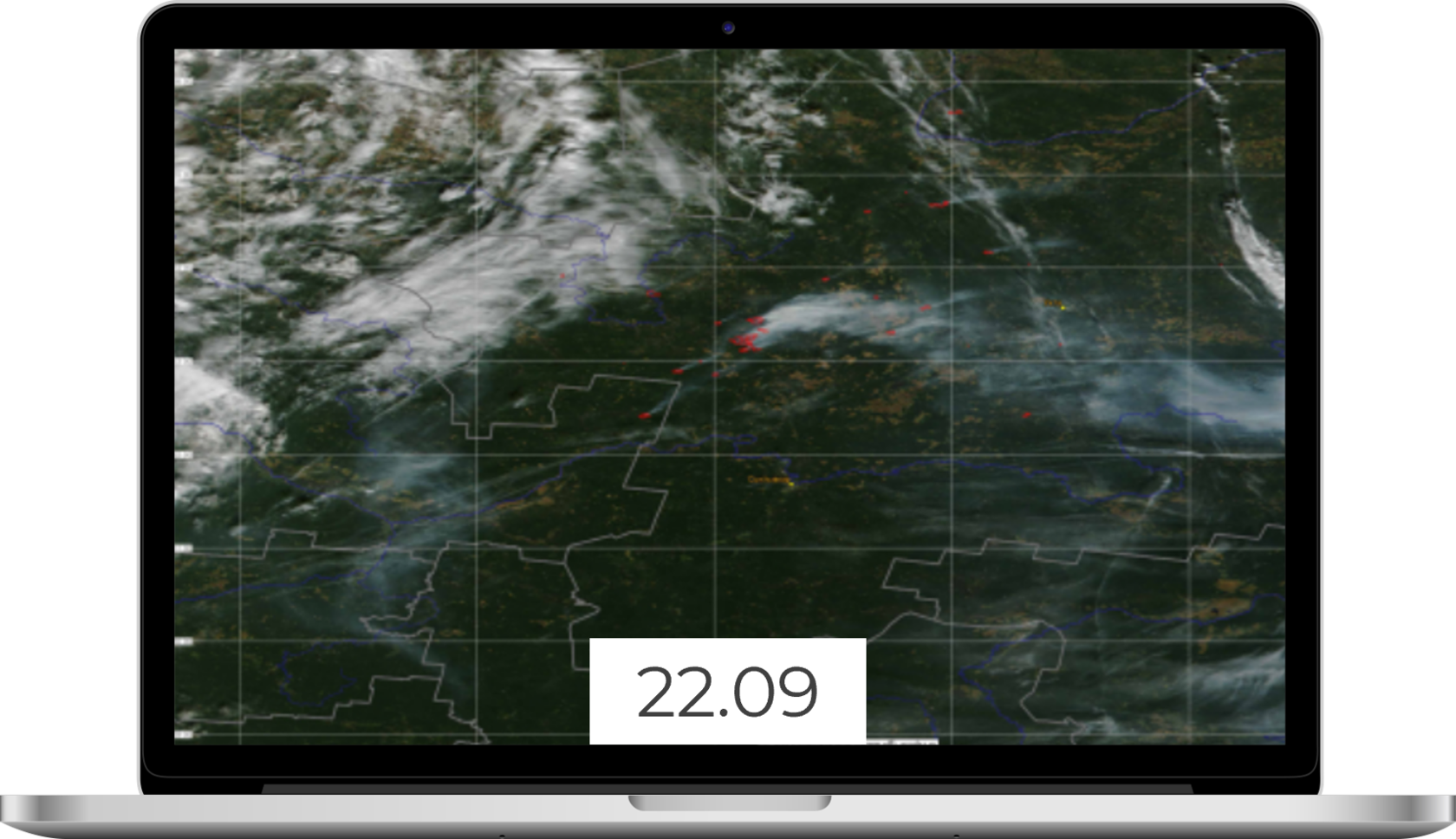
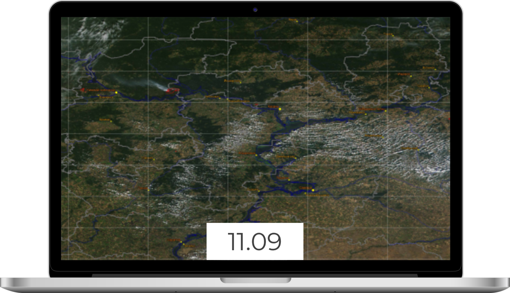
We developed our first result to solve problem of short-term forecast of wildfires in Siberia and Far East:
o In this project we used our last networks and Wasserstein
Generative Adversarial Networks (WGAN) for Identification
of wildfires and fill gaps in data under clouds and smoke
o We made two heuristics for training process of WGAN
o We forecasted future air movements and therefore
vectors of fire movements based on LSTM model
o Based on it we estimated future area of wildfires
in short term (4 hours, 8 hours etc.)
o Moreover we estimated value of precipitation. It needs
for understanding degree of danger of spreading fire
o Our plan for nearest future is to retrain our networks based on ViT (visual transformers). This should raise the quality of the model even more

We discover two heuristics for training process of WGANs. We don’t want to show
it totally but we may explain it in common
it totally but we may explain it in common
First is special augmentation of images, which helps us to train our WGAN fast and improve quality
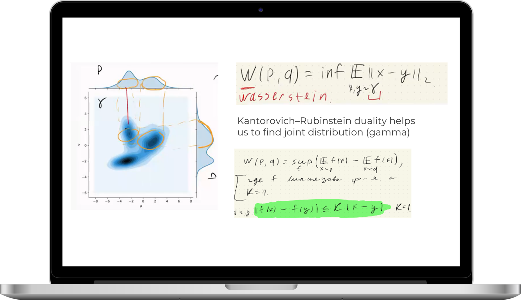
We found a heuristic for strengthening of Kantorovich–Rubinstein duality. It strongly helps us to train. Details in next slides


HOW WE MADE PROJECT WITH FOREST CLEARINGS
We started with manual detection of trees next automated
it with Neural networks segmentation with well precision:
oTook 20 000 photos (20 000 km) from Boeing data. Spring/summer/autumn/ winter in a equal proportions
oPassed photos through ESRGAN to increase resolution
oAnnotated photo dataset in CVAT/PhotoMode (microsoft/intel software) application as polygons (annotated dataset by students)
oThe problem of segmentation of different types of trees is solved using images at different times of the year
oTrained several segmentation models. Metric IOU
oUNET 91,0%,
oDeepLabv3 93,5%,
oResNeST200 96.5%
oCombined GEO tiff segmentation with coordinates of supports of high-voltage lines and safe width standards
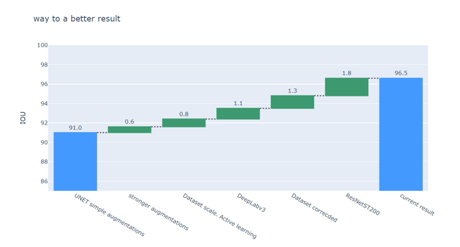
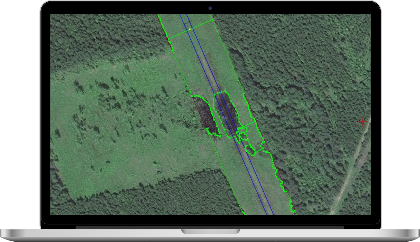
So we have got rectangles/bands with dangerous trees segmented. We can calculate area where trees should be cut down (see example www.cmncosmos.com)

WASSERSTEIN DISTANCE AND KANTOROVICH–RUBINSTEIN DUALITY
WGAN is GAN with using Wasserstein metrics as distance
Function f is 1-Lipschitzfunctions according Kantorovich–Rubinstein
We found additional properties
of f and hence adjust standard regularization of loss function
Function f is 1-Lipschitzfunctions according Kantorovich–Rubinstein
We found additional properties
of f and hence adjust standard regularization of loss function

FOREST FIRE MONITORING

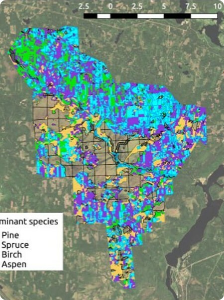
DIFFERENT TREE TYPES SEGMENTATION
We combined satellite data, LIDAR data and ground based surveys of forest
We ve collected dataset using
observations of Novosibirsk Oblast (total area is around 20 000 hectares)
observations of Novosibirsk Oblast (total area is around 20 000 hectares)
Used both
hierarchical classification (aspen/birch
and spruce/pine)
and one-versus-all classification to reach 90,5% of f1 classification score
hierarchical classification (aspen/birch
and spruce/pine)
and one-versus-all classification to reach 90,5% of f1 classification score

SATELLITE ECOSYSTEM
PROJECT
SATELLITE MONITORING
Scale:
up to 30 cm in one pixel
up to 30 cm in one pixel
Satellite Ecosystem
GOALS:

Creating a Digital Terrain Model (DTM)
Infrastructure monitoring
Various tasks
in agriculture
in agriculture
Oil spill detection
Detecting ships
Monitoring of ice conditions
Cartography
Emergency monitoring
Satellite Ecosystem
INFRASTRUCTURE MONITORING
There are more than 13,000 power transmission lines in Russia
Voltage grade:
110 - 750 kV
110 - 750 kV
Total length:
Over 490,000 km
Over 490,000 km
Annual costs:
EUR 1bn
EUR 1bn
Measures planned to make power grid more reliable and reduce accidents:


Surveillance of high voltage power line routes
Vegetation clearance
nearby power line routes
nearby power line routes
Monitoring power line conditions
in inaccessible and remote places
in inaccessible and remote places


MAIN CHALLENGES:
The winning bidder is a company asking for the lowest price
The cost of verifying whether the service was properly provided can exceed 10% of the service cost
You do not know how much money you need to pay for the service without a clear picture of the situation at the site
FINDING A CONTRACTOR
SERVICE ACCEPTANCE PROCEDURE
COST ESTIMATION
04
03
02
ROSSETI PJSC'S OFFER
Developing a service for satellite monitoring of woodland near power lines
Developing a service for satellite monitoring of woodland near power lines
PROJECT OUTLINE
Satellite Ecosystem
It is impossible to determine the number of trees needed to be cut down
for the power line which is 2,000 km away
from the nearest community
for the power line which is 2,000 km away
from the nearest community
DETERMINING THE SCOPE OF WORK / SERVICES
01
Pilot project:
MVP SOLUTIONS
Satellite Ecosystem
01
02
The actual scope of work was estimated, which was not in line with the one announced by the Contractor
PROJECT OUTCOME


1,000 km

EQUIPMENT
⁕ 1 server: 128 cores, 1024GB RAM
⁕ 7 workstations with the following features: Core i7 CPU 3GHz, 6 cores, 16GB RAM
⁕ System for storing work projects must contain 50TB SSD arrays (10 units)
⁕ 2PB HDD storage system
⁕ Network connection 10 Gbit/sec
⁕ 7 workstations with the following features: Core i7 CPU 3GHz, 6 cores, 16GB RAM
⁕ System for storing work projects must contain 50TB SSD arrays (10 units)
⁕ 2PB HDD storage system
⁕ Network connection 10 Gbit/sec
The task was performed
with the help of the PhotoMod software
Manual labor takes approximately 2 man-hours per km
with the help of the PhotoMod software
Manual labor takes approximately 2 man-hours per km
Pilot project:
MVP SOLUTIONS
Satellite Ecosystem
01
The task was performed
using the PhotoMod software
Manual labor takes approximately 2 man-hours
per km
using the PhotoMod software
Manual labor takes approximately 2 man-hours
per km
PROJECT OUTCOME
1,000 km
EQUIPMENT
⁕1 server: 128 cores, 1024 GB RAM
⁕27 workstations with the following features: Core i7 CPU 3 GHz, 6 cores, 16 GB RAM
⁕System for storing work projects must contain 50TB SSD arrays (10 units)
⁕2PB HDD storage system
⁕Network connection 10 Gbit/sec
⁕27 workstations with the following features: Core i7 CPU 3 GHz, 6 cores, 16 GB RAM
⁕System for storing work projects must contain 50TB SSD arrays (10 units)
⁕2PB HDD storage system
⁕Network connection 10 Gbit/sec

Satellite Ecosystem
Comprehensive scaling up of the service
on prospective inspection of 500,000 km power lines is unfeasible due to the following bottlenecks:
⁕Low level of automation
⁕High level of manual labor
on prospective inspection of 500,000 km power lines is unfeasible due to the following bottlenecks:
⁕Low level of automation
⁕High level of manual labor
1st and 2nd stage takeaways

The turnout for vegetation clearance tenders was low, as it became known that verification of work performance will be mandatory and reliable


Pilot project:
MVP SOLUTIONS
Satellite Ecosystem
01
02
The actual amount and type of usable timber to be obtained during project implementation was determined.
The forecast accuracy level is 73%
The forecast accuracy level is 73%
PROJECT OUTCOME
1,000 km
EQUIPMENT
⁕ 1 server: 128 cores, 1024GB RAM
⁕17 workstations with the following features: Core i7 CPU 3GHz, 6 cores, 16GB RAM
⁕System for storing work projects must contain 50TB SSD arrays (10 units)
⁕2PB HDD storage system
⁕Network connection 10 Gbit/sec
⁕17 workstations with the following features: Core i7 CPU 3GHz, 6 cores, 16GB RAM
⁕System for storing work projects must contain 50TB SSD arrays (10 units)
⁕2PB HDD storage system
⁕Network connection 10 Gbit/sec
The task was performed
with the help of the PhotoMod software
Manual labor takes approximately 12 man-hours
per km
with the help of the PhotoMod software
Manual labor takes approximately 12 man-hours
per km

Satellite Ecosystem
Providing a comprehensive service is unfeasible due to the following bottlenecks:
⁕ Low level of automation
⁕ High level of manual labor
⁕ Low level of automation
⁕ High level of manual labor
3rd stage takeaways
To continue with the project, the process of service provision needs to be automated
MVP SOLUTIONS
Satellite Ecosystem
02
IMAGE ANALYSIS TASKS
*Segmentation grids have evolved in the
following way:
UNET > DeepLabv3 > transformers
following way:
UNET > DeepLabv3 > transformers
Images on which all the objects are identified are subject to the following tasks:
1.Track hazardous objects in an improper place
(e.g., fires or enemy ships)
2.Examine the difference
to the previous frame
to estimate the rate of change
3.Compare the objects' positions, e.g. "to signal that a tree has grown in the power line area"
4.Recalculate transport routes
5.3D reconstruction
and photogrammetry (Google
Earth, 2GIS, Microsoft Flight Simulator, JSC Racurs)
Other tasks

01
Image segmentation
Determining where the objects of interest are located
(forests, fire sources/fires, swamps, and other objects that are significant
for other purposes: roads,
buildings, vehicles,
ships, oil spills)
Toolkit:
Determining where the objects of interest are located
(forests, fire sources/fires, swamps, and other objects that are significant
for other purposes: roads,
buildings, vehicles,
ships, oil spills)
Toolkit:
- segmentation grids*
- color threshold filters
Satellite Ecosystem
The team has learned how to train a neural network
in the context of solving a task of clearing forest belts
in the context of solving a task of clearing forest belts
4th stage takeaways


The tasks from
the site monitoring category
can be accomplished
the site monitoring category
can be accomplished
The ecosystem imaging technology can be widely used all over the world
